
 Reply With Quote
deeerppppppp!!!!!!!!!!!!!!!!!!!!!!!!!!

3 sigma? No big deal! 1930!
http://www.ncdc.noaa.gov/sotc/nation...6/supplemental
deeerppppppp!!!!!!!!!!!!!!!!!!!!!!!!!!
Oh I'm just waiting for El Nino to take hold later this year. If we get anything about a weak one we're going to really see some heat build in. I think Darrin is just trolling. But its fun to just point out how stupid and shallow the arguments are.
The more extreme weather keeps getting the more no one is going to buy into the bull the deniers spew.
Where are the 1930s?

Be afraid. Be very very afraid.
http://www.uni-mainz.de/eng/15491.php
Uh oh, cartoonist blogger says anomalous years in USA shouldn't be used to infer anything about global climate trends.
http://www.skepticalscience.com/1934...-on-record.htm

You managed to cherry pick from a post on cherry picking!!!!!!!
Holy !!
LOOOOOOOOOOOOOOOOOOOOOOOOOOOOOOOOOOOOL
error bars. Oh wait, there are none.
Pretty funny how hard you try to bury your head. Remain ignorant, Darrin. Its fun watching you flat out intentionally lie.
What does figure four say about European summer temps? http://sciences.blogs.liberation.fr/...limatiques.pdf
I don't think that Darrin understand what they are trying to say when they say:
If there is a cooling trend and then all of a sudden there is a e in the opposite direction what should that tell you? I think this may be another case of him not even reading something before he posts it.In addition to the cold and warm phases, the new climate curve also exhibits a phenomenon that was not expected in this form. For the first time, researchers have now been able to use the data derived from tree-rings to precisely calculate a much longer-term cooling trend that has been playing out over the past 2,000 years. Their findings demonstrate that this trend involves a cooling of -0.3°C per millennium due to gradual changes to the position of the sun and an increase in the distance between the Earth and the sun.
This figure we calculated may not seem particularly significant, says Esper, however, it is also not negligible when compared to global warming, which up to now has been less than 1°C. Our results suggest that the large-scale climate reconstruction shown by the Intergovernmental Panel on Climate Change (IPCC) likely underestimate this long-term cooling trend over the past few millennia.
I really hope that Darrin is trolling because otherwise he is really really s my.
Pretty funny how you, of all people, know about North Atlantic Oscillation, but you aren't talking about it.
You think the NAO is driving the extremes we're seeing? wtf?!?!??!
LOOOOOOOOOOOOOOOOOOOOOOOOOOOOOOOOOOOOOOOOOOOOOOOOO OOOOOOOOOOOOOOOOOOOOOOOOOOOOOOOOOOOOL
I actually respect what Manny has to say. You are just a gnat.
Not so much driving, as keeping it around.
You really want to talk about the NAO? I've brought it up before because studies have recently shown that the loss of sea ice can have huge effects on it. In other words, the NAO - just like every other aspect of the climate system - is going to respond to the increase in energy due to anthropogenic climate change.
The NAO is NOT a driver of climatic trends and anyone who tries to make any such assertion is a god damn fool.
I appreciate the extra long lol's tho.
I try.
LOL seriously. Link me to the place where you got the idea the NAO is a factor in the recent extreme weather. This I gotta see.
Just to clarify, I mean recent as in this summer. The NAO can have large affects on winter weather but as I pointed out the NAO is itself feeling the effects of climate change reducing sea ice.
Oh well. You can characterize me however you like. I have no respect for you whatsoever so derision because I annoy you coming from someone such as yourself is meaningless.
OTOH, just like you claimed that graph earlier this year was from BEST when it really came from a denial website you leave out the context of the quote from above when you posted that graph.
I call you deceptive because i can point to things such as the above. When I call you a sophist i again can point to things like the above because you take anything that you think might support your case and present it without thought. the appearance is much more important to you than the reality.
You can call me an insect but at the same time it is demonstrable that you are deceptive as is your sophistry. I will leave to others to decide which is more compelling.
I'm going to cut you some slack then, because that article is incredibly poorly written. The NAO does not pull weather patterns across the nation at all. Systems move across the country because of the circulation pattern of the atmosphere (Basically the three celled model).
The situation we're seeing right now a pretty standard summertime pattern where you get the subtropical high stretching out to the west. The main differnece is that there is more energy in the system.The heat burning up the country right now is due in part to a persistent high pressure system, also called a heat ridge or dome, which parked itself over the mountain west, and has now shifted east into the Midwest and Southeast. The system is unfortunately stuck in place, Weber said, because of a slowdown of the North Atlantic Oscillation, a climate pattern that pulls weather patterns eastward across the country.
This "blocking" of the Atlantic has caused the jet stream, which normally ferries air from west to east across the United States, to buckle and trap heat in the Midwest and Southeast, Weber told OurAmazingPlanet.
High and dry
That's not unusual in the summer, said National Weather Service meteorologist Greg Carbin. But this pattern of hot air does cover a broader area than usual, and the total amount of hot air is greater, stretching higher up in the atmosphere than normal, he said.
Where the article gets confused, is in associating the NAO block in winter (the NAO phase in winter can either make a warmer situation or allow some seriously cold air to spill south) with the current warmth.
That article is really atrociously written but I really don't see how anyone without a decent understanding of the NAO and sub tropical high would actually know that.
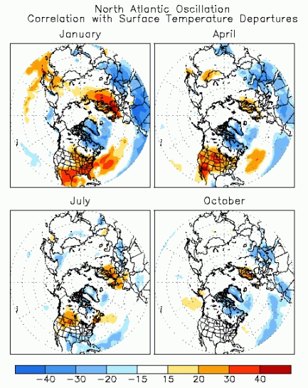
This map shows the level of corrolation between temps and the NAO condition. In July, most of the country shows no coloration with the exception of the NW. I wasn't aware of that corolation in the NW (and now I'm kinda curious as to why thats the case). However, you can see that in the winter its a huge player in the temperatures we experience.
From that article...
Unfortunately, the heat doesn't look likely to dissipate soon, with the National Weather Service expecting warmer-than-usual temperatures to continue for the remainder of the summer across much of the country. The southwest and Rocky Mountains could be in for a reprieve soon, however, thanks to the beginning of the North American typhoon, which is predicted to start bringing moisture and cooler temperatures into the area later this week, Weber said.
The NA Monsoon is actually in pretty good swing right now. We got a good deal of rain over the past week here in NM and temps have been fairly low each day after hitting the century mark a bit in late June. Thats standard for this part of the country at this time of the year, though.
I'll wait and see where 2012 ends up as a data point. May merely be another blip on the radar. Just seems like AGW alarmists are orgasmic over local weather events. Just Google "this is what global warming looks like" to see what i mean.
There are currently 1 users browsing this thread. (0 members and 1 guests)
 Posting Permissions