Reply With Quote
There hasn't been a hurricane this size hit Texas since the 70s and this asshole is talking about what's going to happen.
Current forecast is 2-6 inches for SA-Austin area.

There hasn't been a hurricane this size hit Texas since the 70s and this asshole is talking about what's going to happen.

Finally starting to see some warming near the center as the convection on the Eastern eyewall deepens.

We are you seeing that?
Eye looks like it really wants to come out on visible now.


I remember Katrina strengthened like crazy while it was just off the coast, fortunately our city isn't below sea level tbh

Not on the weather channel.
They JUST showed 12-18 inches Fri/Saturday with a stall.
That would be channel 1225 for ATT.
That's just an estimate. Harvey was a tropical storm yesterday and it's projected to hit as a Cat 3 possibly 4 and stall out over Texas.
some might be thinking that this might be another one of those 'weird' canes , where that separate band of convection to the north-east stays there forever.
But it's really common in the Gulf b/c the inflow is asymmetric. Camille had it while it was an uber cat 5.
They are already running out of gas in Gregory. Just talked to a friend. They are evacuating, Rockport thru port lavaca.
Storm surge coupled with this thing hanging in the same general area after landfall for maybe 72 hours before heading back out into the Gulf is setting up for a major disaster.
Flood of 98 and wasn't even as big of a storm as this one, it rained over 16 inches in 4-5 days, this could be alot more

Ok. Kens is saying 2-6 along IH35 from SA-Austin on their website. I guess we'll have to see where it goes. Last I saw, most of the plots had it tracking east of SA then taking a sharp turn east and then stalling.
If you google San Antonio weather discussion they have some really good stuff with a lot of meteorology jargon. They don't tend to do rainfall expectations by number though.

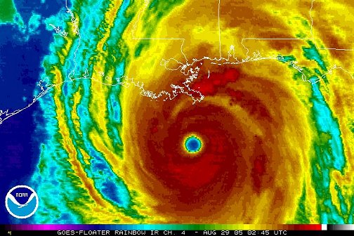
Still a long way to go to get to Katrina. When you see the eye look like this, it's time to get in your car and drive north.

Surfline report for Bob Hall - chart is breaking on shore, highlighted bar shows swells offshore.
I have no idea. I'm just going by what they are saying at the AmericanWeather Forum.
I'm about to become an expert on weather as well as everything else.
This is from a Houston forum.

We're mostly safe in San Antonio and I don't live in an area of it prone to flooding. I'm all good. Stay safe yourself if you're in the danger zone tho', brah.
Sombrero dancing inland between Victoria and Corpus Christi from hour 36 to hour 120. Slowly heading SW just inland near CC at the latter timeframe.
Intensity forecasting for tropical systems is incredibly difficult due to a number of external and internal dynamics that affect the growth and sustainment of such systems.
Harvey has purged all the dry air from itself on the latest GOES 16 image...the center is completely nested within deep convection.
Idk why, but "rodney dangerfart" gave me a good chuckle.
Probably cus farts are funny.
Back to Tropical Storm
Hurricane Harvey Discussion Number 18 NWS National Hurricane Center Miami FL AL092017 400 PM CDT Thu Aug 24 2017 Since the issuance of the special advisory at 1800 UTC, data from a dropsonde released by a NOAA Hurricane Hunter aircraft indicated that Harvey's central pressure has dropped to 976 mb. However, the plane has not measured winds stronger than what was observed by the previous Air Force flight (although the NOAA P3 is flying a research mission at a nonstandard level). For now, the initial intensity will remain 75 kt pending data from another Air Force flight this evening. Harvey's initial motion estimate is 330/9 kt. A strengthening mid-level high over the eastern Gulf of Mexico is expected to push Harvey northwestward by tonight, and a northwest or north-northwest motion should continue up until landfall. However, a stronger mid-level high centered over the western United States is forecast to cause Harvey to slow down considerably and stall near or just inland of the Texas coast by days 3 and 4. After that time, the track models have trended toward showing Harvey moving slowly eastward by day 5, but it's too early to know if the center will remain over land or re-emerge over the northwestern Gulf of Mexico. The track guidance is very tightly clustered for the first 36-48 hours, which covers the period of landfall, but then there is much greater spread in the models after 48 hours when Harvey is forecast to slow down. Such guidance is usually an indication that the cyclone will move very little, which is reflected in the official forecast. Harvey remains in an environment for further strengthening. Vertical shear is low, and the hurricane will be moving over a warm eddy of relatively higher oceanic heat content within the next 12-24 hours. As a result, the NHC intensity forecast calls for additional intensification at least for the next 24 hours, with Harvey expected to attain major hurricane strength on Friday. There may be some fluctuations in intensity up until landfall due to the possibility of an eyewall replacement or cooling of the shallow shelf waters of Texas, but regardless Harvey is forecast to reach the coast as a major hurricane. The intensity forecast after 48 hours is tricky because it all depends on how far inland Harvey moves into Texas. If it stays stalls closer to the coast, as recent model trends have suggested, then the cyclone may be able to maintain a higher intensity with a greater proportion of its circulation remaining over water. For that reason, the updated NHC intensity forecast keeps Harvey as a tropical storm on days 3 through 5, but there is greater-than-normal uncertainty in this part of the forecast. It is critical that users not focus on the exact forecast track of Harvey, since cycle-to-cycle adjustment are likely. All locations within the hurricane and storm surge warning areas should be preparing for the possibility of major hurricane-force winds and life-threatening storm surge.
You can literally see the eye clearing out with more convection popping around the eyewall. Its over 30C waters with high TCHP, low shear, and very moist mid levels. Once the sun goes down and we get a nice temperature differential we could see another period of rapid intensification.
(Having a of a time posting images here compared to what it used to be)

There are currently 1 users browsing this thread. (0 members and 1 guests)
 Posting Permissions