Page 5 of 5 FirstFirst 12345
Results 101 to 124 of 124
  1. #101
    dangerous floater Winehole23's Avatar
    My Team
    San Antonio Spurs
    Join Date
    Nov 2008
    Post Count
    118,365
    may god favor the Texas coastal bend with a hurricane soon, especially the city of Corpus Christi

    Choke Canyon Reservoir and Lake Corpus Christi are the main water sources, which are fed by the Nueces, Frio, and Atascosa rivers (smaller rivers). As of March 2026, the main reservoirs have dropped to critically low levels, below 10% capacity.
    https://www.texastribune.org/2026/03...-water-crisis/

  2. #102
    dangerous floater Winehole23's Avatar
    My Team
    San Antonio Spurs
    Join Date
    Nov 2008
    Post Count
    118,365
    iirc, Cosmic Cowboy is a recreational user of Choke Canyon

    how's it looking these days, CC?

    The imminent depletion of water supplies in Corpus Christi threatens to cut off the flow of jet fuel to Texas airports and other oil exports from one of the nation’s largest petroleum ports, triggering potential shockwaves through energy markets in Texas and beyond.


    Without significant rainfall, Corpus Christi is headed for a “water emergency” within months and total depletion of the system next year, according to the city’s website. “The impacts are going to be felt tremendously through the state, if not internationally,” said Sean Strawbridge, former CEO of the Port of Corpus Christi Authority, the nation’s top port for crude oil exports, in a 40-minute interview Thursday. “This should be no surprise to anybody. We were talking about this over a decade ago.”

    Other current and former officials, alarmed at what they call a lack of preparations, have suggested the potential for an economic crisis involving mass layoffs, disruption of fuel supplies and billions of dollars in emergency spending to avoid an evacuation of the city.

  3. #103
    Mr. John Wayne CosmicCowboy's Avatar
    My Team
    San Antonio Spurs
    Join Date
    Mar 2003
    Post Count
    44,173
    iirc, Cosmic Cowboy is a recreational user of Choke Canyon

    how's it looking these days, CC?
    I have never been to Choke Canyon. I mostly salt water fish both inshore and offshore. Only freshwater I do is with the grandkids off my dock at McQueeney. But yeah, Corpus is in a world of hurt and about to run out of water.

  4. #104
    dangerous floater Winehole23's Avatar
    My Team
    San Antonio Spurs
    Join Date
    Nov 2008
    Post Count
    118,365
    the snowpack was already low in the west from an unusally hot and dry winter

    the intense heat dome plus ongoing drought conditions bode ill for the Colorado River basin

    “This will be … the warmest winter on record and the driest, and those two things don’t help us when we’re trying to figure out how to fill Lake Powell and Lake Mead,” Gene Shawcroft, Utah’s Colorado River negotiator, said at the Utah Water Users conference on Tuesday.


    The nation’s two largest reservoirs that store water for millions of people across the Southwest are nearing critical lows. Lake Powell was 25% full and Lake Mead was 34% full as of March 15.


    The Bureau of Reclamation’s latest most probable forecast for Powell shows the reservoir reaching “power pool,” or 3,490 feet, by the end of this year. At that level, Glen Canyon Dam can no longer generate electricity and sustain releases downstream to California, Arizona, Nevada and Mexico.
    https://www.sltrib.com/news/environm...ns-water-utah/

  5. #105
    dangerous floater Winehole23's Avatar
    My Team
    San Antonio Spurs
    Join Date
    Nov 2008
    Post Count
    118,365
    Clayton’s team uses a modeling system that compares current data to historical observations. “We use the past to mirror what we expect in the present,” he said. But this year, there’s no good comparison.


    Because of this, he recommends water managers look at the lowest probable forecast rather than the most likely forecast this year.


    “We have some obvious, very serious challenges in terms of managing our water,” Clayton said.

  6. #106
    dangerous floater Winehole23's Avatar
    My Team
    San Antonio Spurs
    Join Date
    Nov 2008
    Post Count
    118,365
    The seven states in the Colorado River Basin have been at an impasse over future management of the river. The states continue to negotiate and will meet in person on Thursday “to see if there’s any common ground,” Shawcroft said.


    Current guidelines for managing the river in dry years expire this year, and a new plan for operating Powell and Mead must be in place by Oct. 1, Shawcroft added.


    The bureau is currently undergoing an environmental review process for possible paths forward, but without a seven-state agreement, it has limited legal authorities, according to the draft environmental impact statement.

  7. #107
    dangerous floater Winehole23's Avatar
    My Team
    San Antonio Spurs
    Join Date
    Nov 2008
    Post Count
    118,365
    How much water is released is likely to be a matter of controversy, however. The Lower Colorado River Basin states of California, Arizona and Nevada want more water released from upstream reservoirs into Powell. They argue those reservoirs were initially approved in the 1950s to store enough extra water to ensure the Upper Basin states can meet required obligations to deliver water to Lake Mead. Mead, at the Arizona-Nevada border, stores water for delivery to the Lower Basin states for drinking and irrigation.


    The Lower Basin's argument is disputed by the Upper Basin states of Colorado, Utah, New Mexico and Wyoming.


    "Their contention is those other reservoirs were built to satisfy their needs," Wegner said.

    What's clear is that if river flows drop as low as some experts fear, there will definitely be less water coming to Arizona, California and Nevada from Lake Mead.
    https://tucson.com/news/local/subscr...44797c531.html

  8. #108
    dangerous floater Winehole23's Avatar
    My Team
    San Antonio Spurs
    Join Date
    Nov 2008
    Post Count
    118,365
    a tropical storm would be very welcome in Corpus Christi


    Without a shift in weather patterns, the City of Corpus Christi expects to enact emergency restrictions on water use in September, according to draft do ents slated for release at a City Council meeting on Tuesday morning.


    The 43-page draft presentation, provided to Inside Climate News by a source close to Corpus Christi’s water department, describes plans to mandate 25 percent cuts for all of its water customers, including nearly 500,000 people in the Coastal Bend region of Texas, as well as one of the state’s leading petrochemical and refinery hubs.


    The order to curtail water would be an unprecedented conservation measure, meant to draw out the timeline to depletion of the region’s reservoirs, which could occur within the next year.


    “We’re running out of water,” said U.S. Rep. Michael Cloud, a Republican who represents the region, in comments to Energy Secretary Chris Wright during a budget hearing last week in Washington, D.C. “I want to just remind you of that.”
    https://insideclimatenews.org/news/2...-restrictions/

  9. #109
    dangerous floater Winehole23's Avatar
    My Team
    San Antonio Spurs
    Join Date
    Nov 2008
    Post Count
    118,365
    The desiccation of the river’s headwaters is shrinking a critical water lifeline for about 35 million people and 5 million acres of farmland across the Southwest, from the Rockies to Southern California and northern Mexico.


    With less snowmelt feeding the Colorado River, its giant reservoirs are dropping to dangerously low levels. Lake Mead, the country’s largest reservoir near Las Vegas, is now 28% full.


    Lake Powell, the second-largest reservoir, is at just 24%, approaching a point where there won’t be enough water behind Glen Canyon Dam to continue generating electricity. To keep hydropower going as long as possible, the Trump administration is taking emergency measures, releasing extra water from another reservoir upstream to raise the lake level.


    Experts and state water managers say it’s clear the seven states that rely on the river need to drastically cut water use to avert disaster before the supply in reservoirs is exhausted.
    https://archive.is/B7LzG#selection-3255.0-3315.64

  10. #110
    Alleged Michigander ChumpDumper's Avatar
    My Team
    San Antonio Spurs
    Join Date
    May 2003
    Post Count
    154,588
    I'm building a data center on my almond farm in Kingman.

  11. #111
    dangerous floater Winehole23's Avatar
    My Team
    San Antonio Spurs
    Join Date
    Nov 2008
    Post Count
    118,365
    I'm building a data center on my almond farm in Kingman.
    sounds about right

    On June 26, the County Manager of Henrico County, Virginia, John Vithoulkas, sent an email to thousands of county employees asking them to help the local government conserve electricity. “Beginning July 1st, the rate we pay for electricity used in all Henrico County government and school facilities will increase dramatically — by 25%, increasing costs by an estimated $5 million next fiscal year. We anticipate more rate increases for electricity in the years ahead,” a copy of the email obtained by 404 Media said (emphasis his).

    Henrico County is a community of more than 350,000 people in eastern Virginia just outside of Richmond. It also hosts 37 data centers and there are plans to build 17 more, including plans to convert hundreds of acres of Civil War battlefields into data centers. Thanks to its proximity to DC and vast amounts of land, Henrico County became a data center hub seemingly overnight and its services clients big and small. Meta built a data center there in 2017.

    “To mitigate the impact of higher electric costs, I am asking that we, collectively, make slight adjustments to conserve electricity across our individual workspaces,” Vithoulkas wrote in the email. “Turn off your lights when leaving your workspace, including when you leave for the day. Turn off your computers/laptops at the end of each workday. If your workspace has windows, adjust the blinds to manage heat from sunlight. Unplug any appliances, chargers, or other electrical items when they are not in use. Please limit use of (or refrain altogether from using) space heaters.
    https://www.404media.co/henrico-virg...gy-cost-email/

  12. #112
    dangerous floater Winehole23's Avatar
    My Team
    San Antonio Spurs
    Join Date
    Nov 2008
    Post Count
    118,365


    https://en.wikipedia.org/wiki/Joseph...dia/File:Gwsan

    Around a quarter of the U.S. food supply is grown in California's Central Valley. Most of its crops, like rice, fruit trees and nut trees, are water-intensive and require extensive groundwater pumping during droughts. Over time, heavy water extraction has contributed to changes in the aquifer systems under the San Joaquin and Sacramento valleys. Although some of these changes can be reversed, a new study, published in the Proceedings of the National Academy of Sciences, indicates that large parts of the Sacramento Valley may have undergone irreversible ground compaction during recent droughts, leading to a permanent loss of groundwater storage.
    https://phys.org/news/2026-07-califo...y-aquifer.html

  13. #113
    dangerous floater Winehole23's Avatar
    My Team
    San Antonio Spurs
    Join Date
    Nov 2008
    Post Count
    118,365
    historic drought

    Lake Mead, the largest reservoir in the United States, has plummeted to its lowest water level since it was filled some 90 years ago, another sign of the crisis plaguing the Colorado River system.

    Water levels at the reservoir, which straddles the Arizona-Nevada border outside Las Vegas, hit 1,040.4 feet (317.1 meters) above sea level on Friday, according to federal data. That’s just below the record set on July 28, 2022, according to the U.S. Bureau of Reclamation.

    “It’s extremely significant and extremely concerning. You have three-quarters of the population of the Colorado River Basin, some 30 million people, who are directly impacted by risks to Lake Mead,” said J.B. Hamby, chairman of the Colorado River Board of California and a board member of the Imperial Irrigation District, the largest user of the river’s water.

    https://apnews.com/article/colorado-...1360f467b2579d

  14. #114
    dangerous floater Winehole23's Avatar
    My Team
    San Antonio Spurs
    Join Date
    Nov 2008
    Post Count
    118,365
    The federal proposal called for the Lower Basin states of Arizona, California and Nevada to take less water. The Bureau of Reclamation, which released the plan, said it was flexible: Deeper cuts could happen in drier times, while states would have more time to collectively agree on how to manage the scarce resources.

    Severe drought in 2022on Lake Mead, which is held back by Hoover Dam, exposed human remains and forced water officials in Las Vegas to pump water from deeper within the reservoir to continue to supply water to millions of people.

    Levels at Lake Powell have dropped so much that it has become difficult to descend far enough to reach the water. Boat ramps have had to move, shut down or be built anew.

    Lake Mead and Lake Powell are not alone. Of the 54 Western reservoirs tracked by the Bureau of Reclamation, nine recently recorded their lowest levels in the last three decades.

    Federal officials do not believe the record will stay where it is. According to modeling done in July, Lake Mead is forecast to continue dropping through much of the rest of the year.

  15. #115
    dangerous floater Winehole23's Avatar
    My Team
    San Antonio Spurs
    Join Date
    Nov 2008
    Post Count
    118,365
    Lake Powell is approaching minimum power pool

    As of June 2026, Lake Powell rests at an elevation of 3,528 feet—only a few dozen feet above minimum power pool. Schmidt says the Bureau of Reclamation isn’t treating 3,490 feet as the magic switch that flips all at once; the agency wants to keep Powell closer to 3,500 feet to preserve a margin of safety.

    “People really ought to think about this as a natural disaster,” says Sharon B. Megdal, director of the Water Resources Research Center at the University of Arizona. “For years I’ve said that people need to be vigilant, they need to be aware, but they don’t have to be alarmed.

    “Well,” she continues, “I’ve been alarmed this last year.”

    In April 2026, the Bureau of Reclamation began triage. The agency announced plans to release 660,000 to 1 million acre-feet of water from Flaming Gorge Reservoir, upstream on the Green River in northeastern Utah, while holding back roughly 1.48 million acre-feet that would otherwise flow from Lake Powell to Lake Mead. The government is basically borrowing water from one part of the system and withholding it from another to keep Glen Canyon Dam above its danger zone. Hoover can retrieve water from elevations lower than that of Glen Canyon, but if Powell falls below minimum power pool—and especially toward dead pool—it could spell the end of hydropower all along the Colorado River.
    https://www.popularmechanics.com/sci...-power-crisis/

  16. #116
    dangerous floater Winehole23's Avatar
    My Team
    San Antonio Spurs
    Join Date
    Nov 2008
    Post Count
    118,365
    ~56% of Colorado River water goes to grow feed for livestock


  17. #117
    Mr. John Wayne CosmicCowboy's Avatar
    My Team
    San Antonio Spurs
    Join Date
    Mar 2003
    Post Count
    44,173
    That 56% of water used to grow hay? Around a third of that hay is exported all around the world with Japan, China, Saudi Arabia, and Korea nbeing the largest buyers.

  18. #118
    dangerous floater Winehole23's Avatar
    My Team
    San Antonio Spurs
    Join Date
    Nov 2008
    Post Count
    118,365
    That 56% of water used to grow hay? Around a third of that hay is exported all around the world with Japan, China, Saudi Arabia, and Korea being the largest buyers.
    Alfalfa's the big one in the lower Colorado -- I think there's something posted upstream about alfalfa and Saudi Arabia

  19. #119
    Mr. John Wayne CosmicCowboy's Avatar
    My Team
    San Antonio Spurs
    Join Date
    Mar 2003
    Post Count
    44,173
    Alfalfa's the big one in the lower Colorado -- I think there's something posted upstream about alfalfa and Saudi Arabia
    Yeah Saudi Arabia banned growing alfalfa in their country for dairy cows and bought up thousands of acres in arizona to grow and export and are pumping huge quan ies of free water from their aquifer.

  20. #120
    dangerous floater Winehole23's Avatar
    My Team
    San Antonio Spurs
    Join Date
    Nov 2008
    Post Count
    118,365
    Yeah Saudi Arabia banned growing alfalfa in their country for dairy cows and bought up thousands of acres in arizona to grow and export and are pumping huge quan ies of free water from their aquifer.
    Our feudal first discovery/capture rights have screwed it all up. If users had to pay market value for water we wouldn't be growing alfalfa and lettuce in deserts.

  21. #121
    dangerous floater Winehole23's Avatar
    My Team
    San Antonio Spurs
    Join Date
    Nov 2008
    Post Count
    118,365
    another thing that screwed it all up is that water allocations were made during the wettest period in the Colorado River basin in the last 1000 years, though we probably wouldn't have been able to know it then

  22. #122
    dangerous floater Winehole23's Avatar
    My Team
    San Antonio Spurs
    Join Date
    Nov 2008
    Post Count
    118,365
    this very long Jack Herrera article is pretty great

    Last year I spent seven months traveling the entire length of the Rio Grande basin, from the headwaters high in the mountains of Colorado to the terminus on the Gulf of Mexico, some 1,900 miles later. I wanted to understand the disaster gripping the river, and what might be done to stop it. While the imperiled Colorado River tends to attract the headlines, the Rio Grande is in an even more severe state of collapse. Just 15 percent of its natural flow makes it out to the Gulf each year.


    For years these changes have been obvious and ominous. I’ve spent most of my career reporting along the border, and in places where I’d once watched migrants swim against deep, treacherous currents, the water has receded to a muddy trickle. Experts have been worried about the river for decades, yet I’d assumed the threat of it vanishing was, at worst, decades away. I didn’t realize it had already begun.
    https://www.texasmonthly.com/interac...de-water-wars/

  23. #123
    dangerous floater Winehole23's Avatar
    My Team
    San Antonio Spurs
    Join Date
    Nov 2008
    Post Count
    118,365
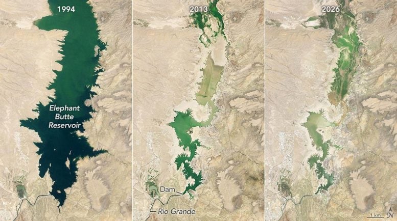
    Together, these conditions helped push Elephant Butte Reservoir, the largest reservoir in New Mexico, to its lowest level since 1971. When the image above was captured on July 27, 2026 (right), the reservoir held just 1.4 percent of its capacity.


    The contrast with earlier decades is striking. Elephant Butte was nearly full on June 2, 1994 (left), and water levels remained relatively high through much of the period from 1985 to 2000. During another major drought, the reservoir reached its annual low of 2.9 percent capacity on July 8, 2013 (center).
    https://scitechdaily.com/new-mexicos...ow-its-at-1-4/

  24. #124
    dangerous floater Winehole23's Avatar
    My Team
    San Antonio Spurs
    Join Date
    Nov 2008
    Post Count
    118,365
    possible solution: charge alfalfa farmers market rates for water

Thread Information

Users Browsing this Thread

There are currently 1 users browsing this thread. (0 members and 1 guests)

Posting Permissions

  • You may not post new threads
  • You may not post replies
  • You may not post attachments
  • You may not edit your posts
  •