

 Reply With Quote
Also if you don't trust The Weather Channel, NOAA has us at 64 by September 2nd. Which would put 70 very much in striking distance.
https://forecast.weather.gov/MapClic...2=-98.5054&e=1

This gets us to 73 as of September 9th

Also if you don't trust The Weather Channel, NOAA has us at 64 by September 2nd. Which would put 70 very much in striking distance.
https://forecast.weather.gov/MapClic...2=-98.5054&e=1

baseline bum
What do you have on your temp right now?
Mine is showing as 105 degrees at present. Though, tomorrow rainy and under 100.
Airport 105, my neighborhood 108

Loud and boomers sinking down from the north
This may be the break in the absurd hot temps
Rain rain rain
Bring it
OMG, I would die in that kind of indoor heat. I'd be booking it up north no matter how high gas prices are. My body, my nose, my head, my stomach, just can't take that kind of indoor heat sustained.
My AC is on 68 and trucking along nicely
So today we officially broke the record for all time days at or above 100 degrees in San Antonio. What a legendary day to behold and to be a part of it, standing here in the great old City of San Antonio.
(with the AC on 68 in a 2300 sqft house)
106 in my neighborhood a couple miles from Sea World right now.
Rain in the forecast tomorrow.
Waco dropped from 104 at 2PM to 72 now. God I hope we get that kind of rain cooling. Front is just north of Round Rock right now.
Jeez that's close! Moving fast and south, too. Kind of reminds me of that tornado that hit Jarrell. Supercell ahead of a big rain front in late May that just kept trucking south and then stalled over Jarrell and rapidly intensified into an F5 tornado before merging with the western periphery of the front.
The hourly rain forecast on TWC gives a 15% chance of overnight precip in SA and around 40% tomorrow, though I have to imagine it'd be higher than that.
Wundermap shows the front having just crossed 410, but I'm still seeing south winds on weather.com. It dropped downtown Austin from 110 to 90.

I used to like the blogs on that website before they got rid of them.
Their weather and hurricane forecasting on the regular site was always kind of meh and semi inaccurate though.
TWC's forecast says that we in SA won't be getting any north winds until 10PM and the relief will be very minimal, only lowering the temperature by 3-5 degrees or so. The forecast overnight low is 81. Miserable.
Last edited by Millennial_Messiah; 08-27-2023 at 06:42 PM.
Meanwile on the TS/Hurricane Idalia front, seems like Governor Desantis will have some cud to chew on with regards to his next statement on climate change for the September debate.
Currently, the official NOAA NHC forecast is for a 100MPH (Cat. 2) hurricane Idalia landfall, but I'm thinking it's probably too conservative/bearish of a forecast given the rapid intensification in the Gulf we've seen in hurricanes since Harvey 2017:
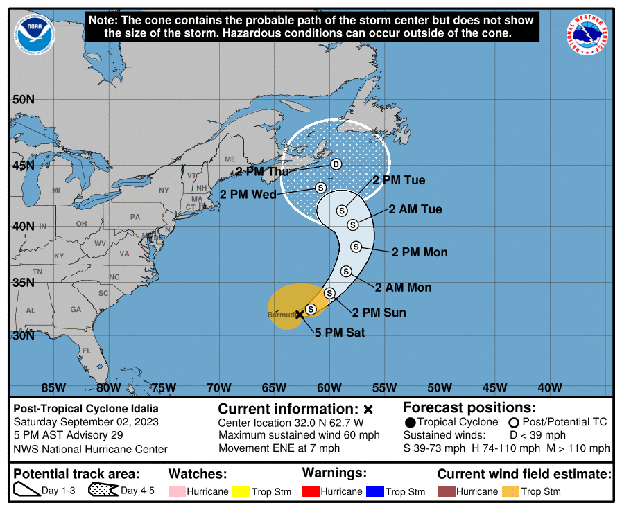
The good news is the armpit part of the Big Bend of Florida is the most sparsely populated part of the state. However if you shift the cone east... or even if the track follows the eastern edge of that cone... we will be looking at a massive worst-case scenario catastrophe for Tampa, worse than Ian last year because a north-tracking storm into Pinellas County will essentially push the storm surge of the Tampa Bay into Tampa like Katrina pushed Lake Pontchartrain into NOLA in 2005 eighteen years ago. Especially if Idalia becomes Cat. 3 or worse.
Wait and see.
KENS 5 at 6pm says tomorrow's forecast high and heat index are 101 and 109 respectively, drastically different from TWC's more bearish and wetter forecast. We'll just see. I do believe we're overdue for drought-busting rain though, especially considering the massive El Nino present right now in the East Pacific.
Classic El Nino in place right now, with a scalding hot equator south of the Americas and scalding hot NW Pacific and virtually all of Arctica with record northern hemisphere sea ice loss:
Also notably, the cool water anomalies in the Southern hemisphere near Antarctica aren't really there and are instead quite neutral, meaning 2023 is definitely a net year for total global warming, not just Northern hemisphere warming or simply a polar shift.
Lots of hot anomalies to go around, but cool anomalies are scattered and scarce.
Houston at 106 is just absolutely insane considering the humidity there. What's the heat index, got to be like 120+? This is like South India or Thailand or Bangladeshi level stuff.
Winds still forecast to be southerly for 2-3 more hours in San Antonio and minimal temperature relief, no rainfall expected tonight
Bulverde at 87, New Braunfels 93 despite neither seeing any rain. Sounds pretty nice for 7PM.
Universal City dropped to 95 now with a NE wind. ing feels amazing outside after how hot the afternoon was.
And I'm still at 102 at 7:17 P.M. One block into Medina county west of Bexar, near Potranco road. FML.
Oh, didn't know you were on the NE side. The front is still at least an hour away from me, then.
I have family friends in Bulverde. We drive up there once a year usually Thanksgiving break week in November. They've got a nice swimming pool and they really like living on the Comal County side and without the Bexar county regulations and government.
They have a few acres, wild deer, and their house backs up to a forest. They can dig giant mud piles, grow their grass as tall as they want, and shoot guns without getting a knock at their door. Must be a nice lifestyle. Except for the fact it's still .....South Texas.
LOL right on the line of the front. we're going to be in the 80s, maybe even mid 80s by 8PM. Ain't seen that in a while.

It's raining. Praise Allah
There are currently 1 users browsing this thread. (0 members and 1 guests)
 Posting Permissions

