

 Reply With Quote
It dosen't matter, you will still have to worry about Tropical Storm Josephine which will become a category 3 Hurricane within the next 72 hours

This ing sucks. I'm going to the Dominican Republic on Sunday so I'm rooting for it to go as far north as possible.
It dosen't matter, you will still have to worry about Tropical Storm Josephine which will become a category 3 Hurricane within the next 72 hours

Ike explodes! Minimal shear overnight. He's cat 3 already!
Also, he's beginning to show characteristics of an annular hurricane. This does not bode well for the east coast.

CH, is Ike still predicted to go into the Gulf or is he supposed to take the northern curve to the east coast?

Ike is now a category 4 hurricane with 135 mph winds!Ike has rapidly intensified this evening. An eye became apparent in
conventional satellite imagery shortly after 2100 UTC. Since that
time the eye has become more distinct with a ring of very cold
clouds tops surrounding it. The latest Dvorak data T-numbers were
t6.0 and raw ADT estimates from UW-CIMSS have averaged t6.2 since
2045 UTC. Based on these estimates the initial intensity is set
at 115 kt...making Ike a category four hurricane. Some additional
strengthening is possible during the next 12 hours or so...this
will largely be controlled by eye-wall replacement cycles. However
both the global models and SHIPS guidance indicate increasing
northeasterly shear in about 24 hours and it is difficult to
predict how an intense hurricane like Ike will be affected by this
shear. The NHC intensity forecast indicates some weakening between
24-72 hours due to the shear...but not as much as indicated by the
SHIPS guidance. At days 4 and 5...it appears that the shear will
decrease so re-strengthening is predicted at that time.
The initial motion estimate is 295/15. The track guidance agrees
on a continued west-northwestward motion during the next 24 hours.
During the middle portion of the forecast period...a mid-level
ridge is expected to build to the north of the cyclone...and the
models unanimously respond by turning Ike west-southwestward. The
lingering question that remains at the longer range is when Ike
will move around the western periphery of the ridge. The
model spread remains quite large at days 4 and 5. The GFDL is on
the left side of the guidance with a track near Hispaniola and
eastern Cuba...while the GFS and UKMET show a position to the
northeast of the Bahamas. For now...the official track is between
these possible solutions and is in best agreement with the
HWRF...the 12z ECMWF...and the model consensus.
Forecast positions and Max winds
initial 04/0300z 22.1n 54.1w 115 kt
12hr VT 04/1200z 23.1n 56.2w 115 kt
24hr VT 05/0000z 24.0n 58.7w 105 kt
36hr VT 05/1200z 24.3n 61.0w 105 kt
48hr VT 06/0000z 23.8n 63.6w 100 kt
72hr VT 07/0000z 22.5n 68.5w 100 kt
96hr VT 08/0000z 22.5n 72.0w 110 kt
120hr VT 09/0000z 24.0n 75.5w 115 kt
$$
forecaster Brown
This has to be one of the most rapidly intensifying hurricanes in Atlantic history. He's showing a perfect donut shape and looks absolutely ferocious. Reminds me a little of Andrew, actually.
holy he is strengthening rapidlyy

Damn, Ike transformed quick. It was just a tropical storm earlier today I believe. It looks like it'll plow right through Miami/South Florida, then enter the Gulf Coast for who knows what.
This thread le should be updated.

Rack B!
Very nicely played!
Sorry, I didn't know that I could edit the le. I thought only Kori,LJ, Slomo, and Mitja were the only ones.
Nevermind...
Right now the models are pretty split. It would be exceedingly rare for this storm to move into the Gulf right now, but that high above it might push it far south enough to do just that.
I'd bank (pardon the pun) on a Florida landfall and then Ike following the coast of the eastern seaboard to North Carolina.
In fact if you look at the historical tracks no storm has made it to the gulf or Florida.http://www.wunderground.com/tropical...o.html#a_topad

I think you can only edit thread les in the first minute or so after you post it. After that you can't change it. You can PM Kori if you'd like it changed.

Note to those staring hurricane threads: Just use the name ie Gustav. Thats your tip for the day.
Fifth fastest 12 hour pressure drop in any storm although that may just be for the Atlantic basin. I don't agree its looking annular at all. Annular storms intensify slowly and steadily - they don't do that Ike just did. Furthermore, Annular storms lose their spiral bands and just have a large CDO in the middle. All the microwave scans of Ike clearly show spiral bands.
Tough to say where it ends up. I hope it just recurves out to sea but I'm not sure how likely that is. Hannah is likely going to strengthen the high to the north and might leave path of slightly lower pressure in its wake. If this is the case then Ike would likely have a tendency to follow Hannah's path in a very weak general motion.
Well, he's not going to recurve for a while. There's a huge ridge of high pressure moving from his NW that will be pushing east and keeping him on his westerly course.
Point taken, however I would submit that we only have about 90 years worth of reliable data to back this assumption. I would not set it in stone as a Law of Nature yet. With that high in place, and this hurricane showing highly annular characteristics, I think a lot of our models will be useless in predicting where Ike moves.In fact if you look at the historical tracks no storm has made it to the gulf or Florida.http://www.wunderground.com/tropical...o.html#a_topad

See, a smart guy like Weather Manny knows not to constrain his thread les.....
I think the odds of this thing making it into the Gulf are really small. I think the odds of this storm hitting the East Coast are larger, but still small. By far the most likely scenario is a recurve out to sea.
Here's to praying that he does recurve out to sea...
just a stupid question here but what would happen if let's say hannah strengthens into a strong hurricane and suddenly shifts to the west into the gulf...will Ike follow? that would be a dooms day scenario
What steering force do you propose will recurve it? And how can you be sure that an annular hurricane will be affected as we expect? We know very little about them except that they seem to ignore atmospheric conditions much more easily than standard hurricanes.
I think Ike is still WAY too far out to see to judge what's going to happen. We couldn't predict Gustav even 8 hours in advance, as he continually jumped to the east of the forecast models. Fey was perhaps the most humbling forecast of a hurricane path in many years. Hannah seems to have experts baffled, as she stalled out several times.
The chances of that happening are almost nil. They are nil. Hannah is clearly beginning to turn. She would have to loop around at this point to head for the Gulf, and if she did, she would run into Ike and be shredded. Hannah is too weak to do much of anything right now. She's at the mercy of the pressure systems around her. Ike is a bit of a different story...
I think everything has a small probability of happening right now.
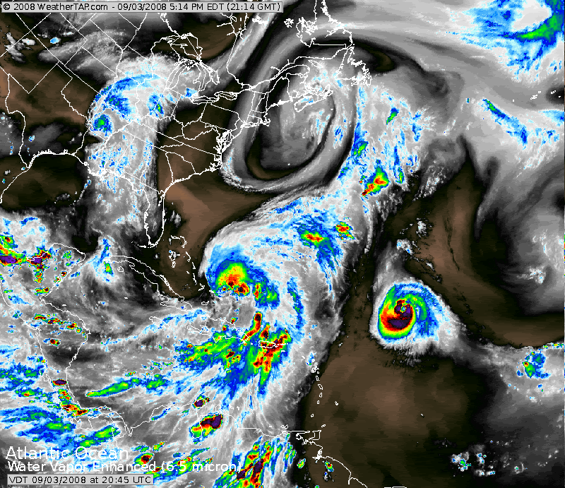
anyone have an updated radar and infrared image of this thing?
Ask, and ye shall receive.

There are currently 1 users browsing this thread. (0 members and 1 guests)
 Posting Permissions


