
 Reply With Quote
I have little sympathy for those who buy residential or business property in a flood plain.
As for the farm land, flooding usually makes it better for future crops.

even arizona is laughing at us

I have little sympathy for those who buy residential or business property in a flood plain.
As for the farm land, flooding usually makes it better for future crops.

This is no ordinary flood WC. And they could probably care less whether you sympathize with them. There will be flooding dozens of miles from the river when they pop that second flood control dam. Thats an action of last resort..admitting they would rather the rural people than the urban people...
They're called poor people and there's a reason they bought there.
Also, this flood far exceeds any event around which flood plain boundaries get established. The about trying to design against Mother Nature is that she's always capable of coming up with a bigger event than the one you planned for. That holds true whether we're talking about floods along the Mississippi, earthquakes in California or Tsunamis in Japan.

And?
Poor people buying rather than renting?
As for exceeding flood boundaries, I say bull . I'm sure geological records would disagree with you.
Nature has cycles. Some long, some short. Never feel assured when someone says "don't worry about it, it's a 1500 year cycle."
Really now... Is anywhere 50 ft. and closer to a waterline safe from long cycle flooding? I say only a fool believes such.
Miles away is how high above the normal water line?
My God man... Look at the size of the area that drains into these waterways.
Though rare, it is a known flood plain.

[WC]
I have no sympathy for anyone buying homes in the western or central US in the path of death from the Yellowstone supervolcano.
[/WC]
[WC]
I have no sympathy for anyone buying homes on the Eastern seaboard in the path of the megatsunami that will come when La Palma falls into the ocean.
[/WC]

That's a clear exaggeration. No wonder you are often wrong. maybe you should line up more facts. Yellowstone is never expected to erupt like it did before. I'll bet if it does, it will likely be when the earths orbit around the sun increases in eccentricity again. That's a good 50k years or so. Tidal forces play havok. The eastern seaboard is not in the Ring of Fire.
The Yellowstone supervolcano is on a 600,000 year cycle and it has been almost 600,000 years. The tsunami that'll wipe out the eastern seaboard won't be caused directly by an earthquake like the one that wiped out Sendai; it'll be the landslide from half of the island of La Palma falling into the ocean after an earthquake, and the tsunami will be hundreds of feet high.
So you're going to be a pathetic ass to top it off...
He had a good point.
My my...
What a twisted mind you both have.

My mind is not quite so twisted.
I don't think you actively want to kill the women and children in the affected areas. I just think maybe you don't care so much if they die.
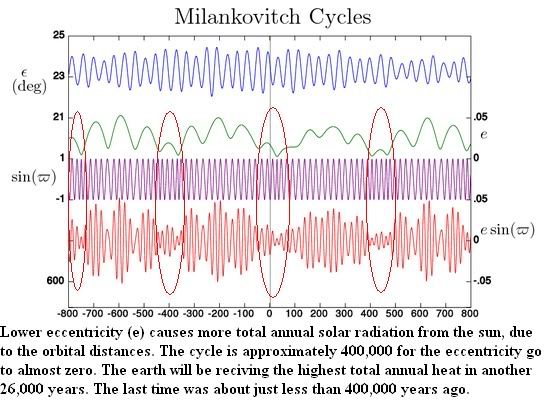
Your problem with the supervolcano idea is that the tidal forces that are part of the equation are diminishing for the next 26k years. They need to be higher, not lower.
Rather than the low points for eccentricity, look at the high (green) points of this graph:
There was one about 600,000 years ago, another about 200,000 years. We won't be in that range of gravitational shearing for another 600,000 years, approximate. The one about 200,000 years from now won't be as intense as what caused that eruption, but I guess it's possible.
Before you say I'm wrong, I suggest you research how these tidal forces work with the rotation of the earth and proximity to the sun, and how eccentricity plays a role. The moon of course will play a role as it's eccentricity and relationship to the earth and sun have impact. Tidal forces not only affect the oceans, but the magma in the earth as well.
As for your Tsunami, I looked at what you're talking about. I thought you meant La Palma, CA at first, and that city is far inland.
The estimated wave is initially more that 80 meters at T+1 hr. in some places, but by the time it reached the Americas, it's about 13 meters max in North America, and 18 meters max at Brazil. It is also estimated that this well not occur for at least another 10,000+years.
The idea of that island collapsing is really remote, but yes. Possible. One article I read estimated it would take a volcanic force of 12,000 to 28,000 billion Newtons to make it happen.
Big difference when you look at probabilities. Neither the Tsunami, or volcano compare in any statistical sense to flooding we see of far shorter timelines.
he's more interested in killing women and children trying to cross the border...just because they're looking for a better life.

http://washingtonexaminer.com/blogs/...sissippi-river
Thats the first mention I've seen of it in the media. And I have no idea who that website or their source The Daily Impact is. I just find it weird this story has gained no traction.
Jeff Masters wrote about this today.
http://www.wunderground.com/blog/Jef...?entrynum=1801The Old River Control Structure's greatest test: the flood of 2011
Flow rates of the Mississippi at the la ude of the Old River Control Structure are expected to exceed the all-time record on Saturday, giving the Old River Control Structure its greatest test since the flood of 1973. Since there are now four structures to control the flooding instead of just the two that existed in 1973, the Old River Control Structure should be able to handle a much greater flow of water. The flood of 2011 is not as large as the maximum 1-in-500 year "Project Flood" that the Old River Control Structure was designed to handle, and the Army Corps of Engineers has expressed confidence that the structure can handle the current flood. However, the system has never been tested in these conditions before. This is a dangerous flood, and very high water levels are expected for many weeks. Unexpected flaws in the design of the Old River Control Structure may give it a few percent chance of failure under these sorts of unprecedented conditions. While I expect that the Old River Control Structure will indeed hold back the great flood of 2011, we also need to be concerned about the levees on either side of the structure. The levees near Old River Control Structure range from 71 - 74 feet high, and the flood is expected to crest at 65.5 feet on May 22. This is, in theory, plenty of levee to handle such a flood, but levees subjected to long periods of pressure can and do fail sometimes, and the Corps has to be super-careful to keep all the levees under constant surveillance and quickly move to repair sand boils or piping problems that might develop. Any failure of a levee on the west bank of the Mississippi could allow the river to jump its banks permanently and carve a new path to the Gulf of Mexico. I'll say more about the potential costs of such an event in a future post.
According to the latest information from the Army Corps the Old River Control Structure is currently passing 624,000 cubic feet per second of water, which is 1% beyond what is intended in a maximum "Project Flood." The flow rate of the Mississippi at New Orleans is at 100% of the maximum Project Flood. These are dangerous flow rates, and makes it likely that the Army Corps will open the Morganza Spillway in the next few days to take pressure off of the Old River Control Structure and New Orleans levees. Neither can be allowed to fail. In theory, the Old River Control Structure can be operated at 140% of a Project Flood, since there are now four control structures instead of just the two that existed in 1973 (flows rates of 300,000 cfs, 350,000 cfs, 320,000 cfs, and 170,000 cfs can go through the Low Sill, Auxiliary, Overbank, and Hydroelectric structures, respectively.) Apparently, the Corps is considering this, as evidenced by their Scenario #3 images they posted yesterday. This is a risky proposition, as the Old River Control Structure would be pushed to its absolute limit in this scenario. It would seem a lower risk proposition to open the Morganza spillway to divert up to 600,000 cfs, unless there are concerns the Corps has they aren't telling us about.
Now that he's written about it, there will probably be a good deal of media attention.
I think its ing stupid they are even considering not opening Morganza. That land is a spillway and while its going to flood a lot of farmland and cost those people a lot of money they knew that going in and its a Spillway. If they choose not to open that spillway and the Old River structure fails its got ENORMOUS consequences and they shouldn't be gambling with that.

Choice #1...open the spillway and on everyone in the path of it. End result, lots of pissed off shat-upons.
Choice #2...don't open it and if the ORS fails, call it an act of God.
I can see the resistance to path #1.
Yeah - considering how little attention they're getting and how little accountability is ever held here in the US then I can see that. Its just ing stupid from a fundamental stand point. The risk reward is terrible.
Good information on the situation to be found here.
http://www.mvn.usace.army.mil/bcarre/missriver.asp
As shown by scenario 3 avoiding opening the spillway confines the flooding quite a bit but then every piece of that system including the levees and the ORCS are put to the absolute limit. I would be shocked if they didn't open Morganza.

Just heard on NPR: Evacuations in LA, Bobby Jindal urges Corps of Engineers to open the Morganza Spillway.
There are currently 1 users browsing this thread. (0 members and 1 guests)
 Posting Permissions