
 Reply With Quote
Wow...
I know you aren't that ignorant. What can't you guys be serious for once.

The amount of water we're talking about here wouldn't even fuel virga. WC understands the sciences but for some odd reason doesn't understand the amount of water it takes for rain.

Wow...
I know you aren't that ignorant. What can't you guys be serious for once.
WC you are the best troll in the history of ST. I want to know who made you. I really do.
What I'm missing is I don't know how many square miles the new salt lake(s) would be. I haven't found how much area us below sea level yet. It would have to be a real large area to work.

What if we flooded Glen Canyon?

How do you know they aren't rainforest? When was the last time you were in Las Vegas or Phoenix? Spare me the lies the liberal media has been feeding you.
This ought to be good...
Who's my maker?

I find it ironic that you'd ask such a question after starting a thread such as this.
I would be off base here if the water created would have little surface area. Do you know about how many square miles would be flooded? If not, your criticism is premature.
Well, can't you get a surface contour map at zero elevation? I'm sure you could piece one together just from zooming around Google Earth.
Even better, USGS topo maps:
http://www.topoquest.com/

go to google maps link I gave above. Go to street view on the road that runs along the eastern edge.
You see that DV floor is very flat so it would be much wider than deep, about 6 miles at max width, but open at both ends, needing two dams.
Many $10Bs. "We're broke!"
And the evaporation would be horrendous, maybe loss of a foot per week. Swimming pools in SA can lose 1"/week on hottest, driest days. And who knows where it would come down again. With that desert air being so dry, it would suck it up and probably never have enough vapor density reach precipitation.
Figure how many foot-acres steady inflow to keep it topped up.
Anyway, there ain't no water available anyway. It's all (over-)spoken for, and becoming more unreliable as the snow pack becomes more unreliable.
You see WC? You've got multiple people helping out in this asinine endeavour now. I think Mannys right. You're master troll. :LOL
Oh come on, give me a break. Have you tried to use those maps?
OK, I found a source that lists Death Valley as having 550 square miles below sea level. Not really close to enough to do as I was hoping.
Thank you all for the help... NOT!
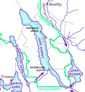
Dude, I gave you a map of the lake that used to be there. Can't you figure this out?
Always the Chumpmonkey...
Are all lakes below sea level? If I remember correctly, very, very few are. I see you are ignorant as to why I ignored your comment.
Yeah, they're the top of the line when it comes to elevation profiles in the US. The contour interval is only 40 feet for the vast majority of their 7.5" quads. On occasion a quad with a really prominent peak (such the Grand Teton quad or the Mount McKinley one) might need to use 80' intervals. What more could you possibly want though? 1' intervals? A continuous function?

Then why would you give such an urgent about how much of Death Valley is below sea level?
You could flood all of Death Valley and it would not have the effect you wanted. Do you know how big some of the largest reservoirs in the world are? You're just a moron.
LOL Lake Mead turned Vegas into a rain forest!!!!
You're an idiot.
I see you don't understand why I call you an idiot.
Tell me, WC: Where do you think the lowest points on this map would be?
Serious question.
Let's see......
You have an old map from Chump.
You have detailed topographical data courtesy of Bumster.
You have a medium within which to do a comparative analysis courtesy of many.
You also have a reasonable supposition as to what your null hypothesis should be courtesy of Manny.
You're akin to a lazy graduate student. You got all of the tools, but you still want someone to build the thesis for you.
There are currently 1 users browsing this thread. (0 members and 1 guests)
 Posting Permissions