Reply With Quote
Rapid weakening expected before landfall, possibly to a TS

When you get cancer I hope they name it Kobe

Rapid weakening expected before landfall, possibly to a TS


Forecast for Patricia: Manzanillo at dire risk
Satellite loops early Friday afternoon showed that Patricia’s cloud tops had begun to warm, indicating weakening, and with wind shear now a moderate 10 - 20 knots and interaction with land beginning to occur, Patricia will likely weaken to 155 - 175 mph winds by landfall. The storm's expected turn toward the northeast has begun, and the storm is beginning to accelerate toward the coast of the Mexican state of Colima.
At particular risk is the city of Manzaillo, a regional center that straddles the back of a bay spanning several miles. On its current track, it apperas that Patricia could make landfall sometime between 6:00 and 10:00 pm EDT just to the northwest of Manzanillo--a trajectory that raises the odds of a catastrophic storm surge in or near Manzanillo. Patricia’s strongest winds are confined to a relatively small area, with hurricane-force winds only spanning a range of 30 miles from Patricia’s center. Category 5 winds of 156+ mph cover an area 15 miles across. Wherever those winds are focused, we can expect gigantic waves atop a devastating surge. An unnamed 1959 hurricane--the deadliest in Northeast Pacific history, with an estimated 1800 direct and indirect fatalities--struck near Manzanillo on October 27 (see embedded YouTube newsreel footage below). In a Friday afternoon blog post, storm surge expect Dr. Hal Needham says he expects a storm surge of 16.5 ft (5 m), which will be accompanied by large, destructive waves. This would be the largest storm surge in the modern history of Western Mexico.
After landfall, Patricia will slam into very rugged terrain, triggering torrential rains with the risk of severe flooding and mudslides. The mountainous trek will shred Patricia’s low-level circulation quickly, but the hurricane’s upper-level circulation will proceed quickly northeastward, arriving near South Texas by Sunday. Models suggest that a nontropical or hybrid low-pressure center may develop near the upper-level center at that point. Patricia’s presence will exacerbate a multi-day rain/flood episode already under way across Texas, with widespread 4” - 8” rainfall amounts across the eastern half of the state expected between now and Monday. Localized totals well over a foot are quite possible.
Super El Niño, not the mythological "anthro- global warming", caused this storm. There was a similar one like this in 1997 (Linda), only difference is that steering currents at the time caused that one to go out to sea instead of making landfall. It's the luck of the draw, and nature acts (and has always acted) independently of human activity. However, liberals will continue to play the blame game against the oil and coal industries and fight to obtain power for themselves over the people by limiting the availability of resources we can use.

Straw man attack.......relatively few people say the hurricane is global warming and most who do repeat the official scientific finding that global warming will increase the prevalence and strength of storms. This is clearly an ell Nino based event but ocean temperature is directly related to storm strength and it is scientific truth that global warming= ocean warming= stronger storms

He responded directly to someone posting an article talking about if it global warming is part of the cause. No straw man there.
Thats is some unbelievable, but real torquing going on within the core.
For the next 12-16 hrs, its gonna be the scariest place on the Planet.
A moment to fathom what is about to happen is offered.

But it is not scientific or statistical truth that there is a long-term "global" warming trend, nor is there truth at all that humans would cause such warming in such a "warm" Earth cycle.
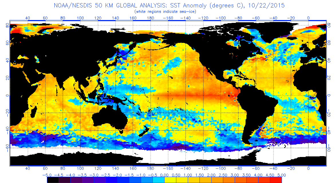
Take a look at the SST anomalies for October 2015:
Notice how warm the equatorial areas are, but the Antarctic is (and has been) much cooler than average. People want to focus on the Arctic sea ice loss when the Antarctic has been consistently gaining ice every year. Stupid propagandists...
Buddy, do you roll you Windows down on a hot day? That's the greenhouse effect. Is space much colder than earth? Why is that, is the greenhouse effect? Do we know what gasses cause that? Are we emmiting more of those gasses? Is there a good reason why emmiting more gasses wouldn't increase global greenhouse effect?
It always struck me as weird that the burden of proof was on scientists when the basic science is so elementary.
Anyway, it was a straw man comment because instead of just saying it's an el Nino event he added anthro climate myth. That's a dangerous belief. Climate denial is fundamentally anti human. It's literally a bet on humans being too dumb to understand grade school science being applied to the real world.
People don't believe in global warming?

This damn El Nino (Not ElNono mind you) weather anomaly is causing hurricane in the eastern pacific and severe drought in the western pacific including my country, we haven't had any rain since April, while the rainy season should have already begun by last month, now it's predicted to only start raining in December, if we got lucky.
The world changes poles every 10k years. The world does have climate change but I do believe we are speeding up that process.

OP, what is Time Warner Cable's stance on the situation?

Good luck to your primos, make sure to send them some wester union when it's over, tbh...
Appreciate the concerns, but luckily I don't have cousins there. Still sucks it's hitting my roots though smh
Unbelievable we are watching history unfold before our eyes here, speaking of eyes the eye of Patricia is doing the wobbling dance and it may be constricting or getting ready to perform an EWRC.

Looks like Patricia is strengthening a bit/putting out some very nasty thunderstorms across the coast just before landfall:
Thoughts to those affected, especially those who were unable to escape/evacuate. The power of this storm is just unreal.
Can't tell if EWRC or pinhole eye like Wilma, if the latter Patricia could strengthen even further prior to landfall in a few hours
More relevant to us: here's the rain forecast between landfall today and Tuesday for Texas (in inches):

I think you are right. Shrinking eyewall stronger winds. Hurricane Hunters getting ready to go back in. Going to be hitting land right between "La Manzilla" and "Manzillo" areas. Could end up being the strongest storm ever to hit planet earth.
One good piece of news is that it looks like the storm is tracking toward the north currently (may be a wobble). This would cause Patricia to miss the most populated areas near Manzanillo, but would put San Patricio possibly in the eastern eyewall. If it keeps moving northward, it would miss San Patricio to the west and could spare that city total destruction. There's not a lot of population between San Patricio and Puerto Vallarta, so if it makes landfall there, the destruction would be limited to smaller towns. Not good, but not a worst case scenario. It looks like Mananillo make be spared the very worst. Lets hope Patricia keeps moving northward away from the highly populated areas.
not sure what poles changing have to do with anything? That's just the magnetic poles.
weather channel showing the eye is definitely losing it's eye apperance. good sign but still obvi dangerous.
There are currently 1 users browsing this thread. (0 members and 1 guests)
 Posting Permissions