Page 2 of 8 FirstFirst 123456 ... LastLast
Results 26 to 50 of 197
  1. #26
    Millennial Messiah UNT Eagles 2016's Avatar
    Post Count
    16,847
    NBA Team
    San Antonio Spurs
    College
    North Texas Mean Green
    High rates of rain and lightning in the eyewall now.

    http://weather.cod.edu/satrad/exper/...=meso1-13-48-1

    That is a perfect eye. I expect the NHC to upgrade Irma to at least 195mph winds with a pressure around ~905 with the next invest. I believe Irma will become the strongest hurricane ever in the Atlantic and could continue to strengthen afterward.

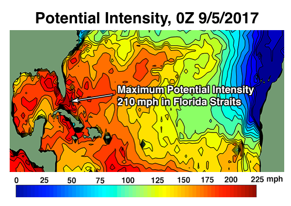
    SSTs support 200mph sustained winds and there is absolutely no shear in the atmosphere to speak of. These are virtually the most ideal conditions possible for a Hurricane to achieve peak strength. The only limit now is how warm the water is.
    Looks like Irma peaked at 185 for now, but after the next eyewall replacement cycle she will temporarily weaken ~15-20 mph but grow double or greater in area and wind field and could deepen closer to 900 mb/200 mph as a much larger-sized hurricane.

    Major hurricane force winds could extend >150 miles from the center after the next EWRC, meaning that any Florida hit would cause major winds and surge for the entire southern Florida Peninsula -- Key West, Tampa, Miami all the way up through Daytona. Orlando isn't on the coast but it would get >115 mph sustained winds and >135mph gusts as well. Within 25-30 miles of the center, you'd get Cat 5 winds -- sustained, not gusts. That's enough to flatten a brick or cement house, knock down high rise resorts and office buildings, and ravage foundations. If this part of the hurricane, say, hits Miami square on -- Katrina will be an afterthought in US history.

  2. #27
    Savvy Veteran spurraider21's Avatar
    Location
    Los Angeles
    Post Count
    100,825
    NBA Team
    San Antonio Spurs
    College
    UCLA Bruins
    Well, Katrina was exacerbated by N.O.'s elevation, shape, levees. It wasn't just the sheer hurricane power we remember

  3. #28
    Veteran SpursforSix's Avatar
    Post Count
    21,159
    NBA Team
    San Antonio Spurs
    Nice little jog north by 18z GFS vs. 12z through 54 hours. Could be enough to matter.

  4. #29
    Veteran SpursforSix's Avatar
    Post Count
    21,159
    NBA Team
    San Antonio Spurs

  5. #30
    Millennial Messiah UNT Eagles 2016's Avatar
    Post Count
    16,847
    NBA Team
    San Antonio Spurs
    College
    North Texas Mean Green
    Yeah spurraider21. The worst part of Category 3 Katrina actually missed NOLA to the east. NOLA was spared of the eyewall and the right front outer part of the hurricane. But the levees were already failing due to age, mediocre build to begin with, and a rain soaker in strong Tropical Storm Cindy earlier in that hurricane season. Katrina was a large storm that dumped a lot of rain and pushed Lake Pontchartrain over the edge and dumped it into the "bowl" parts of NOLA. A category 1 or even TS could have done the same.

    But now it would take a more direct hit and possibly a stronger hurricane because these new levees were built very well. They already survived two somewhat formidable minor hurricane hits in Gustav (2008) and Isaac (2012). Irma at peak intensity hitting NOLA directly would likely cause another Katrina or worse, fortunately it's not forecast to go that far west.

  6. #31
    No darkness Cry Havoc's Avatar
    Location
    Bay Area, CA
    Post Count
    33,683
    NBA Team
    San Antonio Spurs
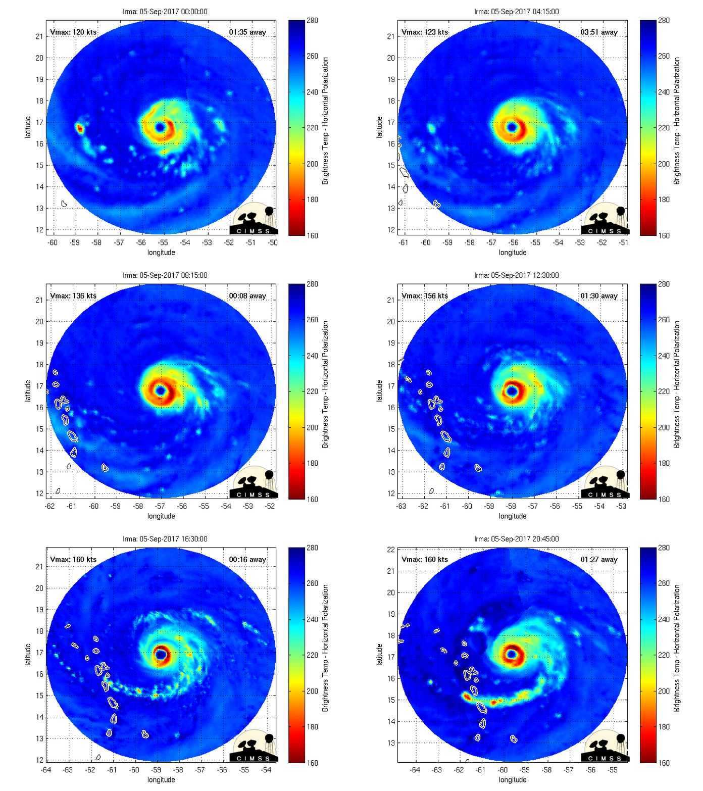
    The donut hole of death. Unreal how symmetrical it is.

    Pressure down to <920 per recon.

  7. #32
    Millennial Messiah UNT Eagles 2016's Avatar
    Post Count
    16,847
    NBA Team
    San Antonio Spurs
    College
    North Texas Mean Green
    18z GFS run just took Irma out to sea instead of hitting Florida.

  8. #33
    Veteran
    Post Count
    20,702
    NBA Team
    San Antonio Spurs
    She's an evil looking

  9. #34
    Millennial Messiah UNT Eagles 2016's Avatar
    Post Count
    16,847
    NBA Team
    San Antonio Spurs
    College
    North Texas Mean Green
    She's an evil looking
    Moving WNW now, definitely a NW component. Could still recurve and miss the US entirely

  10. #35
    faggy opinion + certainty Mark Celibate's Avatar
    Post Count
    4,496
    NBA Team
    Dallas Mavericks
    College
    Texas Tech Red Raiders
    Well, Katrina was exacerbated by N.O.'s elevation, shape, levees. It wasn't just the sheer hurricane power we remember
    yep, after first hand experience with Harvey it's clear that N.O.'s shoddy infrastructure all the way around is what caused it to be a catastrophe. If Houston's two dams had broken...holy .

  11. #36
    No darkness Cry Havoc's Avatar
    Location
    Bay Area, CA
    Post Count
    33,683
    NBA Team
    San Antonio Spurs
    Recon found 199mph winds just 80ft off the surface. Unreal. Still a 180mph storm but with a central pressure of 917.

  12. #37
    Millennial Messiah UNT Eagles 2016's Avatar
    Post Count
    16,847
    NBA Team
    San Antonio Spurs
    College
    North Texas Mean Green
    Recon found 199mph winds just 80ft off the surface. Unreal. Still a 180mph storm but with a central pressure of 917.
    so it weakened? I wonder if it'll only be a weak cat 5 or strong cat 4 at landfall

  13. #38
    俺はまんこが大好きなんだよ baseline bum's Avatar
    Post Count
    97,883
    NBA Team
    San Antonio Spurs
    College
    UCLA Bruins
    Irma is much stronger than Andrew.
    Andrew was at 175 mph when it hit Florida. I'd be really surprised to see Irma be as strong when it makes US mainland landfall after running through Puerto Rico, Haiti, and the Dominican Republic.

  14. #39
    No darkness Cry Havoc's Avatar
    Location
    Bay Area, CA
    Post Count
    33,683
    NBA Team
    San Antonio Spurs
    so it weakened? I wonder if it'll only be a weak cat 5 or strong cat 4 at landfall
    Depends on the land interaction. As of now waters right off the coast are warm enough to support a 7.5 or even 8.0 on the Dvorak. It's bathwater all the way up to Florida for Irma and with minimal shear it's the worst case scenario as far as how strong Irma will be at landfall.

  15. #40
    No darkness Cry Havoc's Avatar
    Location
    Bay Area, CA
    Post Count
    33,683
    NBA Team
    San Antonio Spurs
    so it weakened? I wonder if it'll only be a weak cat 5 or strong cat 4 at landfall
    Also they kept the intensity at 185mph per the 2000 update.

  16. #41
    Veteran InRareForm's Avatar
    Location
    Los Angeles
    Post Count
    8,644
    NBA Team
    San Antonio Spurs
    30 mile eye is crazy

  17. #42
    TB 2 TB Silver&Black's Avatar
    Post Count
    17,516
    NBA Team
    San Antonio Spurs
    College
    Mississippi State Bulldogs
    Nice knowing you Puerto Rico. You shall be missed.

  18. #43
    Watching the collapse benefactor's Avatar
    Name
    benefactor
    Location
    East Texas
    Post Count
    42,233
    NBA Team
    San Antonio Spurs
    College
    Texas Longhorns


  19. #44
    Millennial Messiah UNT Eagles 2016's Avatar
    Post Count
    16,847
    NBA Team
    San Antonio Spurs
    College
    North Texas Mean Green
    210 mph / 890 mb is just fine for a landfall in Miami. Miami can use an ass kicking, also Jay Cutler will be out of a job again.

  20. #45
    Millennial Messiah UNT Eagles 2016's Avatar
    Post Count
    16,847
    NBA Team
    San Antonio Spurs
    College
    North Texas Mean Green
    Irmageddon truly taking her talents to Sowf Beach

  21. #46
    No darkness Cry Havoc's Avatar
    Location
    Bay Area, CA
    Post Count
    33,683
    NBA Team
    San Antonio Spurs


    ing unreal. That looks like an 8.0 with potentially a ring of CDG making landfall.

  22. #47
    Millennial Messiah UNT Eagles 2016's Avatar
    Post Count
    16,847
    NBA Team
    San Antonio Spurs
    College
    North Texas Mean Green


    ing unreal. That looks like an 8.0 with potentially a ring of CDG making landfall.
    150 mile radius (from the eyewall) wide cat 3+ force hurricane winds, 350 miles wide radius of hurricane winds. And those are sustained winds, not gusts. That's before we even discuss rain or storm surge.

  23. #48
    Millennial Messiah UNT Eagles 2016's Avatar
    Post Count
    16,847
    NBA Team
    San Antonio Spurs
    College
    North Texas Mean Green
    HWRF and ECMWF solutions slam into Florida as a cat 5, GFS 18z still makes Irma a fish storm at the last minute. Wait & see

  24. #49
    No darkness Cry Havoc's Avatar
    Location
    Bay Area, CA
    Post Count
    33,683
    NBA Team
    San Antonio Spurs
    HWRF and ECMWF solutions slam into Florida as a cat 5, GFS 18z still makes Irma a fish storm at the last minute. Wait & see
    As usual, follow the Euro and all will be revealed. It's by far the best model we have on the planet right now.

  25. #50
    No darkness Cry Havoc's Avatar
    Location
    Bay Area, CA
    Post Count
    33,683
    NBA Team
    San Antonio Spurs

Thread Information

Users Browsing this Thread

There are currently 1 users browsing this thread. (0 members and 1 guests)

Posting Permissions

  • You may not post new threads
  • You may not post replies
  • You may not post attachments
  • You may not edit your posts
  •